GPS for historic garden rescue
Friends of Mukai will present a program describing the use of land mapping systems in restoring historic gardens at 7 p.m. Wednesday, January 22nd at the Vashon Maury Island Land Trust building. The presentation features Ed Baldwin, Garden Manager of the Highline SeaTac Botanical Garden, and Diane Crawford, Associate Senior Environmental Scientist, Golder Associates, Inc.
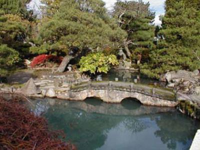
Ed Baldwin will tell the story of the Seike Japanese Garden’s successful move from the third runway area of SeaTac to the Highline SeaTac Botanical Garden. The garden was created by the Shinichi Seike family in 1961 as a memorial for son and brother Toll Seike, who was killed in France while serving with the 442nd Regimental combat team in WWII. The family hired Shintaro Okada, a garden designer from Hiroshima, to help with planning and construction, which began in January and was completed by June 25th with a gala to celebrate the new garden.
With the development of SEATAC’s third runway, the garden, originally part of the Seike family-owned Des Moines Way Nursery, had to be relocated and recreated. The garden was saved by the efforts of four different government agencies and Highline Botanical Garden Foundation. This massive undertaking is considered the largest relocation of a Japanese garden attempted in the United States.
Major efforts throughout the project were focused on the ultimate goal of recreating garden designer Shintaro Okara’s original intent and preserving a significant local, cultural and horticultural treasure. Ed will describe how land mapping technology was used in this effort. The Seike Garden reopened at Highline SeaTac Botanical Garden on June 20, 2006.
Diane Crawford, with over 30 years of experience in environmental investigations, uses field mapping systems, including Global Positioning Systems (GPS), to collect field data to establish latitude, longitude, and elevations or depths for sites within an area, and to delineate linear features and shapes in fields. During a summer visit to the Mukai property, Diane used GPS in conjunction with a smart tablet loaded with satellite imagery to orient specific features as she mapped Kuni Mukai’s garden. She will describe the process and how this technology will be used in future restoration of Kuni’s garden.
The Friends of Mukai program is free and open to the public. Refreshments will be served.
- Login to post comments